[04]Project · Concept, defence
HYPERORB
A man-portable UAS and operator console for high wind, GNSS jamming and extreme cold.
- Client
- Independent study
- Year
- 2026
- Discipline
- Industrial design, Interface, Research
- Deliverables
- Renders, live console, terrain model, route planner
01Challenge
Small tactical drones keep failing in the same three conditions: wind above their rating, GNSS jamming, and cold that drains the battery. The hardware is rarely the whole problem. The operator finds out too late.
02Approach
Design the aircraft around the wind, give it three independent navigation sources, and make every degradation visible on the operator's screen before it becomes a failure.
03Result
A concept aircraft, a live operator console, a terrain and wind model built from onboard LIDAR, and a route planner that shows the cost of every choice.
04Aircraft
Built around the wind, not just rated for it.


05Specification
Design targets. Built to meet MIL-STD-810H and IP54, with a STANAG 4586 vehicle-specific module so existing NATO ground control stations can command it. Not certified figures.
- Class
- Group 2 · man-portable VTOL quadrotor
- Wind
- 80 km/h sustained · 110 km/h gustsLaunch and recovery in gusts up to 70 km/h
- Navigation
- Multi-constellation GNSS, anti-jam arrayVisual-inertial and terrain-relative fallback
- Endurance
- 70–110 minHeated battery, cold-adjusted prediction
- Payload
- 6–10 kg · modular, quick release
- Sensors
- EO/IR gimbal · laser rangefinder · LIDAR
- Range
- 30 km direct · 60 km+ with mesh relay
- Operating
- −32 °C to +55 °C · ceiling 4500 m
- Deployment
- Backpack · under 10 min to launch
- Mass
- MTOW ≈ 13 kgPacks into one backpack, 62 × 40 × 26 cm
- Datalink
- Dual-band, frequency-hopping mesh · AES-256Switches band automatically under jamming
- Supply chain
- NDAA-compliant sourcing by designSecure boot and signed firmware
- Training
- Operator qualified in 3 daysSame console in the simulator and in the field
- Field maintenance
- Tool-less rotor, arm and battery swapLine-replaceable units, under 15 min on site
- Ground station
- HyperOrb GCS · handheld, dual-stickSunlight-readable display · dual-band datalink
06In the field
One operator, one backpack, one ridge.
07Ground station
Every degradation is on screen before it matters.
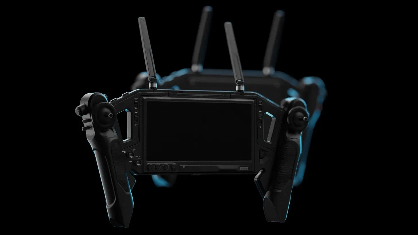
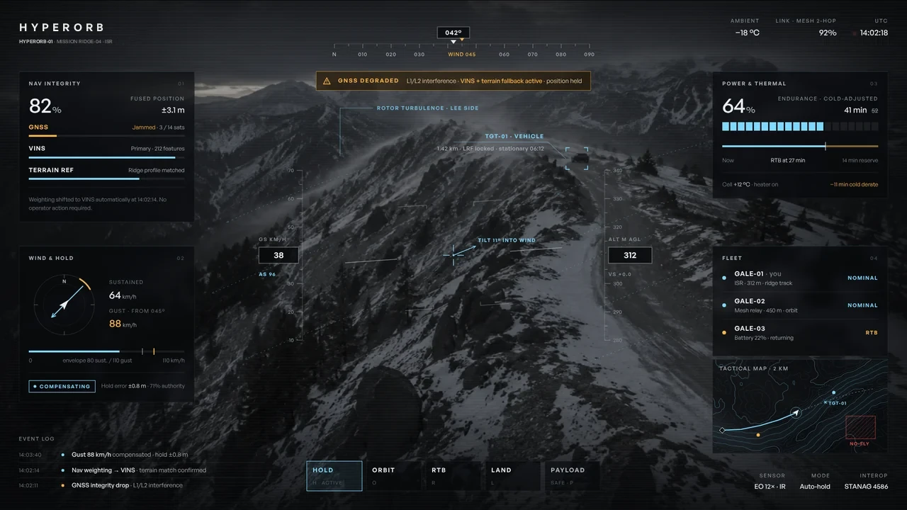
HyperOrb GCS, the handheld ground station. Mission RIDGE-04: five seconds in, GNSS is jammed. Five seconds later, an 88 km/h gust hits the aircraft.

Nav integrity01
Wind & hold02
Power & thermal03
Fleet04
Nav integrity
Three sources, one confidence number. When GNSS is jammed, weighting shifts to vision and terrain in view of the operator.
Wind and hold
Gusts are drawn against the aircraft's own limits, so the remaining control authority is always visible.
Power and thermal
Endurance is corrected for temperature, and the return point is drawn on the timeline.
08Terrain and wind
The aircraft maps the air it flies through.
Onboard LIDAR builds the terrain in flight. The wind model runs on top: speed-up over the crest, rotor turbulence in the lee.
09Route planning
The hidden route is not always the safe one.
Behind the ridge, HyperOrb is out of sight of the EW site but inside the rotor turbulence. The planner shows concealment, turbulence, GNSS exposure and battery side by side, and what each choice gives up.
Route analysisWind-aware
| A · Lee masked | B · Windward |
|---|
Built to recede. The operator sees the aircraft's state, not the interface.
10Gallery
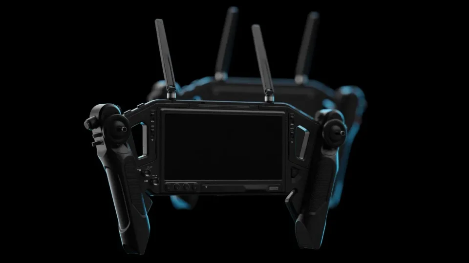
Under the light.


11About the project
Why HyperOrb exists
Public reporting on small tactical drones since 2023 keeps describing the same pattern.1–3 Satellite navigation is jammed. Batteries lose capacity in the cold. Wind exceeds what the aircraft was rated for. And in most cases the operator had no clear view of the system degrading until it was too late to act. This is not one manufacturer's problem. It is the most frequently cited gap across the whole small tactical class, and it is a design problem as much as an engineering one.
HyperOrb is SCC's answer to that gap: an independent concept study, built to show that the team understands the operational problem, not only how to make it look good.
The thesis
Autonomy must not hide the state of the system from the operator. In bad conditions, a tactical drone's reliability is proven by what the operator can see and understand in real time, not by a figure in a brochure. Every decision in the project follows from that sentence.
Positioning
HyperOrb is a Group 2, man-portable VTOL aircraft, differentiated on two axes. First, physical tolerance of wind and weather above the class average. Second, transparency of system state treated as a design priority from the start, not as a feature added at the end.
The aircraft
The rotors sit inside rings. Ducted rotors are safer close to the ground and less sensitive to crosswind on the blades, so the silhouette communicates wind before any text has to. The chassis is specified in carbon fibre and magnesium, the same approach real platforms in this class take. The finish is matte, low-reflectivity dark grey and olive, with no gloss and no printed branding; the HyperOrb wordmark is debossed, not printed. The quick-release payload bay stays visible as a seam on the hull, so the aircraft reads as a system that is upgraded, not a sealed box. Carrying it in a backpack is part of its identity, not just a line in the spec.
Specification
The targets were set to realistically exceed the published figures of comparable small tactical platforms, used as a benchmark, never copied.4 They are: 80 km/h sustained wind with 110 km/h gusts, launch and recovery in gusts up to 70 km/h, 70 to 110 minutes of endurance, a 6 to 10 kg modular payload, 30 km of direct range and 60 km or more with a mesh relay, a 4500 m ceiling, and operation from −32 °C to +55 °C. Navigation combines multi-constellation GNSS behind an anti-jam array with visual-inertial and terrain-relative fallbacks, and an edge compute module classifies objects and estimates the wind field on board.
The ground station and console
The console is the core of the case study, because it is where the thesis is either proven or not. Its rule is simple: every degradation of state, whether wind, navigation or battery, must become a visible fact on screen before it affects the mission, not an alarm after it. The navigation panel fuses GNSS, visual-inertial and terrain sources into a single confidence number and raises a fallback banner the moment GNSS is jammed. Wind and hold draws gusts against the aircraft's own limits, with a live compensating state. Power and thermal corrects remaining minutes for temperature, so the operator knows the flight will be shorter before it is. A minimal fleet panel shows the other aircraft, and the action bar keeps hold, orbit, return and land one press away. The console runs on HyperOrb GCS, a handheld, dual-stick ground station designed by SCC.
Terrain, wind and planning
The map is not a satellite image. The terrain is built from data the aircraft collects itself with onboard LIDAR, and a wind model runs on top of it: where the ridge blocks the flow, where it speeds up over the crest, and where rotor turbulence forms in the lee. The route planner uses the same model to compare two routes, and makes the trade-off explicit. The route hidden behind the ridge is out of sight of the electronic warfare site, but it flies straight through the turbulence. HyperOrb shows the cost of each choice instead of choosing silently.
Standards
The study refers to real standards that engineers and procurement teams recognise immediately: MIL-STD-810H for environmental testing, IP54 for dust and water ingress, and STANAG 4586, which lets existing NATO ground control stations command the aircraft through a vehicle-specific module. That last one answers the most common procurement question, whether a new system will work with the stations already in service. The aircraft is described as designed to meet these standards, the accepted wording for a concept at this stage, not as certified.
How it was made
The work started with research, not visuals: a dossier covering the problem, the positioning, the specification, the industrial design direction and the console's zones. The aircraft renders were generated from that brief and art-directed over several rounds for light, material and negative space. The console, the field scene, the terrain and wind model and the route planner were then built as live, animated interfaces, so they can be explored rather than just looked at.
HyperOrb is an independent concept study by SCC. It is a speculative design, not a fielded system, and it is not affiliated with any manufacturer. Specifications are design targets and standards are targets the design is built to meet, not certifications. Terrain, mission data and the scenario are fictional and generated for this study.
- Task & Purpose, on RUSI's “Meatgrinder” report: around 10,000 drones lost a month to electronic warfare, May 2023
- The Kyiv Independent, after The Wall Street Journal: small drones pushed off route by jamming, April 2024
- The Kyiv Independent: cold makes drone batteries unreliable, February 2026
- Teledyne FLIR SkyRanger R70, published wind rating used as the benchmark
12Briefing
Request a briefing on HyperOrb.
For defence, procurement and partner teams: the full specification, a live console walkthrough and the design rationale, presented by the SCC team.
- MTOW
- ≈ 13 kg
- Range
- 30 km · 60 km mesh
- Datalink
- AES-256, frequency-hopping
- Wind
- 80 / 110 km/h